Get a free quote

636.922.1001

[email protected]

  • Surveys
    • Boundary Survey
    • Alta ACSM Surveys
    • Surveyor’s Real Property Report
    • Topographic Surveying
    • Plot Plans
  • Elevation Certificates
    • Flood Insurance and Elevation Certificates
    • FEMA / FIRM
  • Blog
    • Surveying Related
    • Flood Zones
    • Commercial
  • F.A.Q
  • About us
  • Videos
But I Need MORE Information!

But I Need MORE Information!

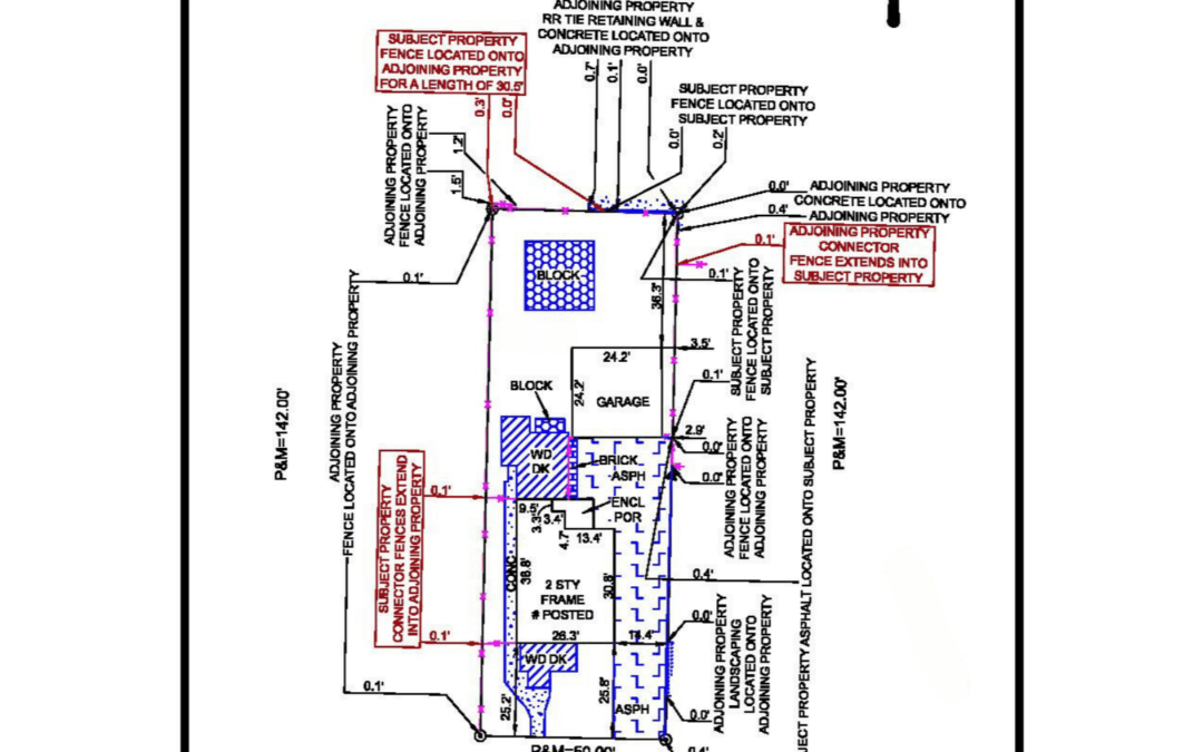
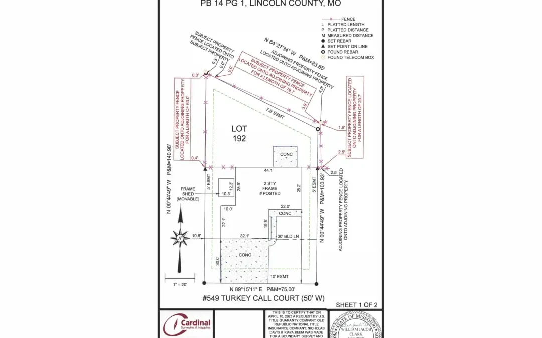
by Shelly C | Nov 29, 2023 | Boundary survey, Common Ground, Property Lines, Surveying Related

There are times when you may need more information than what a standard boundary and improvement survey may show. You may in fact need more than just the property corners marked showing just one point along the property line. We can provide you with as much...
Don’t Use the Utility Box to Build Your Fence!

Don’t Use the Utility Box to Build Your Fence!

by Shelly C | Sep 28, 2023 | Boundary survey, Property Lines

I understand that it is tempting to just build the fence using the utility boxes that you can see. Surely the utility companies put those boxes right where your property corners are located…RIGHT? The thing is utility companies have approximately 10 feet of...
Why can’t you survey only one side of the property?

Why can’t you survey only one side of the property?

by Shelly C | Oct 19, 2016 | Surveying Related

Have you ever done a puzzle? Where did you start – with the edge pieces or with the middle? If you’re like the majority of people, you always start with the edges. Surveying is similar in practice in that in order to know how the middle piece of the puzzle fits, you...

Search

Recent Posts

  • ALTA Survey Series Conclusion: Bringing It All Together.
  • The Utility Box Is Lying to You (About Your Property Line)
  • More Than Just Property Lines: The Value of a Detailed Boundary Survey.
  • The Final Item on Table A: Why the Blank Line Matters
  • Google Maps vs. Reality: The Truth About Property Boundaries

Categories

  • ALTA Survey
  • Assessor
  • Benchmark
  • Boundary survey
  • Commercial
  • Common Ground
  • Drone
  • e-commerce
  • Easement
  • Elevation Certificate
  • Encroachment
  • Flood Zones
  • Land Surveying
  • Marketing
  • National Society Of Professional Surveyors
  • NSPS
  • Property Lines
  • Radio & TV
  • Sales
  • Stake Survey
  • Surveying Related
  • Title Insurance
  • Topographic
  • Uncategorized

Cardinal Surveying & Mapping, Inc 

PO Box 278
Cottleville, MO 63338

ph: 636.922.1001
fx: 636.922.1002

[email protected]

Surveys

Boundary Surveying
Real Property Report
ALTA and ACSM Surveys

Our Site

About Us
Blog
FAQs

Opening hours

Mon – Fri – 8:00 – 05:00
Sat-Sun – Closed

Follow us

  • Follow
  • Follow
  • Follow
  • Follow
  • Follow

Copyright 2024| designed by The One Provider LLC