Get a free quote

636.922.1001

[email protected]

  • Surveys
    • Boundary Survey
    • Alta ACSM Surveys
    • Surveyor’s Real Property Report
    • Topographic Surveying
    • Plot Plans
  • Elevation Certificates
    • Flood Insurance and Elevation Certificates
    • FEMA / FIRM
  • Blog
    • Surveying Related
    • Flood Zones
    • Commercial
  • F.A.Q
  • About us
  • Videos
How can we determine property lines?

How can we determine property lines?

by Shelly C | Feb 14, 2023 | Boundary survey, Common Ground, Encroachment, Property Lines, Surveying Related

If you are getting ready to install a fence or add landscaping, you may be interested in knowing where your property lines are located so that you can ensure that you are staying on your own property. The professional who is most associated with property lines is a...
Differences Between a Boundary and an ALTA Survey

Differences Between a Boundary and an ALTA Survey

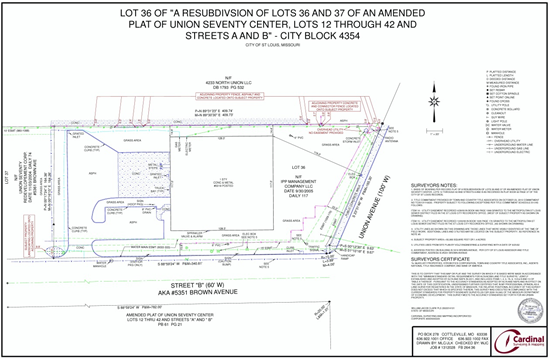
by Shelly C | Oct 21, 2022 | ALTA Survey, Boundary survey, Commercial

While boundary surveys and surveys are very similar in nature there are some specific differences between the two types of surveys. Here is a list of some of the similarities between the two types of surveys: Authorization to perform the survey work is provided by the...

Search

Recent Posts

  • ALTA Survey Series Conclusion: Bringing It All Together.
  • The Utility Box Is Lying to You (About Your Property Line)
  • More Than Just Property Lines: The Value of a Detailed Boundary Survey.
  • The Final Item on Table A: Why the Blank Line Matters
  • Google Maps vs. Reality: The Truth About Property Boundaries

Categories

  • ALTA Survey
  • Assessor
  • Benchmark
  • Boundary survey
  • Commercial
  • Common Ground
  • Drone
  • e-commerce
  • Easement
  • Elevation Certificate
  • Encroachment
  • Flood Zones
  • Land Surveying
  • Marketing
  • National Society Of Professional Surveyors
  • NSPS
  • Property Lines
  • Radio & TV
  • Sales
  • Stake Survey
  • Surveying Related
  • Title Insurance
  • Topographic
  • Uncategorized

Cardinal Surveying & Mapping, Inc 

PO Box 278
Cottleville, MO 63338

ph: 636.922.1001
fx: 636.922.1002

[email protected]

Surveys

Boundary Surveying
Real Property Report
ALTA and ACSM Surveys

Our Site

About Us
Blog
FAQs

Opening hours

Mon – Fri – 8:00 – 05:00
Sat-Sun – Closed

Follow us

  • Follow
  • Follow
  • Follow
  • Follow
  • Follow

Copyright 2024| designed by The One Provider LLC